
Weather for drone pilots
Good to fly right now? 17 METEO answers in a second.
A drone is hundreds of hours of work and serious money — one weather mistake takes it away in a minute. Set your aircraft's limits once, or pick one of 50+ ready-made profiles, and 17 METEO watches the weather, delivers an AI go/no-go verdict with a confidence level, and warns you the moment something's wrong.
- Free
- No ads or subscriptions
- Works worldwide
- Works offline
- OPSEC by default
Readiness traffic light
One glance and you know — fly or wait
No more piecing it together from a dozen tabs and raw numbers. 17 METEO boils it down to a clear verdict with the limiting factor spelled out — plus an hourly forecast for 24 hours and a 15-day outlook.
-
Green — good to fly
Conditions are within your drone's limits. Plan your flight with confidence.
-
Yellow — caution
Borderline: gusts, visibility or signal need attention. Weigh the risk.
-
Red — hold off
Conditions are unsafe to fly. The app tells you when the next green window opens and how long it will last.
AI forecasts that actually work
Real neural weather models — not an “AI” sticker
17 METEO runs on next-generation models that are reshaping world meteorology right now — and it's honest about how much today's forecast can be trusted.
-
AI go/no-go verdict
The NOAA AIGFS neural weather model delivers a fly-or-wait verdict with a confidence level — you see not just the call, but how sure it is.
-
Cross-checked
The AI verdict is automatically checked against a classical physical model — two independent opinions instead of one.
-
Model agreement
A dedicated card shows whether ECMWF, GFS and ICON converge — how much today's forecast can be trusted.
- NOAA AIGFS
- ECMWF
- GFS
- ICON
Features
Everything you need for a confident takeoff
Built for people who fly for a living: aerial photo and video, FPV, inspections, search and rescue, agriculture — any unmanned platform.
-
Traffic-light readiness
Fly or wait — matched to your exact drone, not “average weather”. Always with the limiting factor spelled out.
-
Next green window
When the next safe launch window opens, and how long it will last.
-
50+ drone profiles
DJI Mavic, Mini, Air, Matrice, Autel EVO, Ukrainian and Western professional platforms — or build your own.
-
Winds aloft
Wind and gusts from 10 m up to 3000 m, wind rose and turbulence.
-
Mission altitude
Drag the altitude line — and every card recalculates for your mission.
-
Hour-by-hour forecast
A detailed 24-hour forecast plus a 15-day outlook — with cloud base and visibility.
-
Route analysis
Weather where your aircraft will be in an hour — not where it is now.
-
GNSS monitor & forecast
Satellite health, spoofing alerts and a visible-satellite forecast for your launch window.
-
Storms & geomagnetics
CAPE index, hourly thunderstorm risk and the Kp index with its effect on GPS.
-
Bluetooth anemometer
Ground-truth wind in the field from an external anemometer — not just the forecast.
-
Battery health
Charge and real-world battery state before takeoff, with cold-weather derating.
-
Make it yours
Customize the dashboard and keep only the cards you actually need.
Beyond the air
Air. Sea. Ground.
17 METEO answers the weather question for more than aircraft — naval and ground modes work with the same profiles and windows.
-
Air
The readiness light, winds aloft, launch windows and the AI verdict — tuned to your aircraft profile.
-
Sea
Wave height, sea state and departure windows for surface platforms.
-
Ground
Soil trafficability, night-frost windows, fords and control-link range.
See it in action
Everything a pilot needs, on one screen
Real screens from the app — from the readiness verdict to wind by altitude and the GNSS monitor.
-
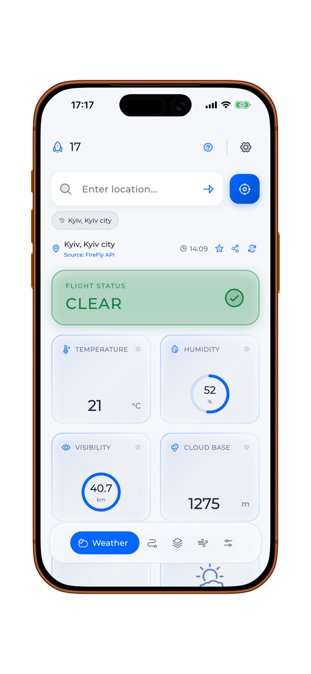
Flight status — the answer at a glance
-
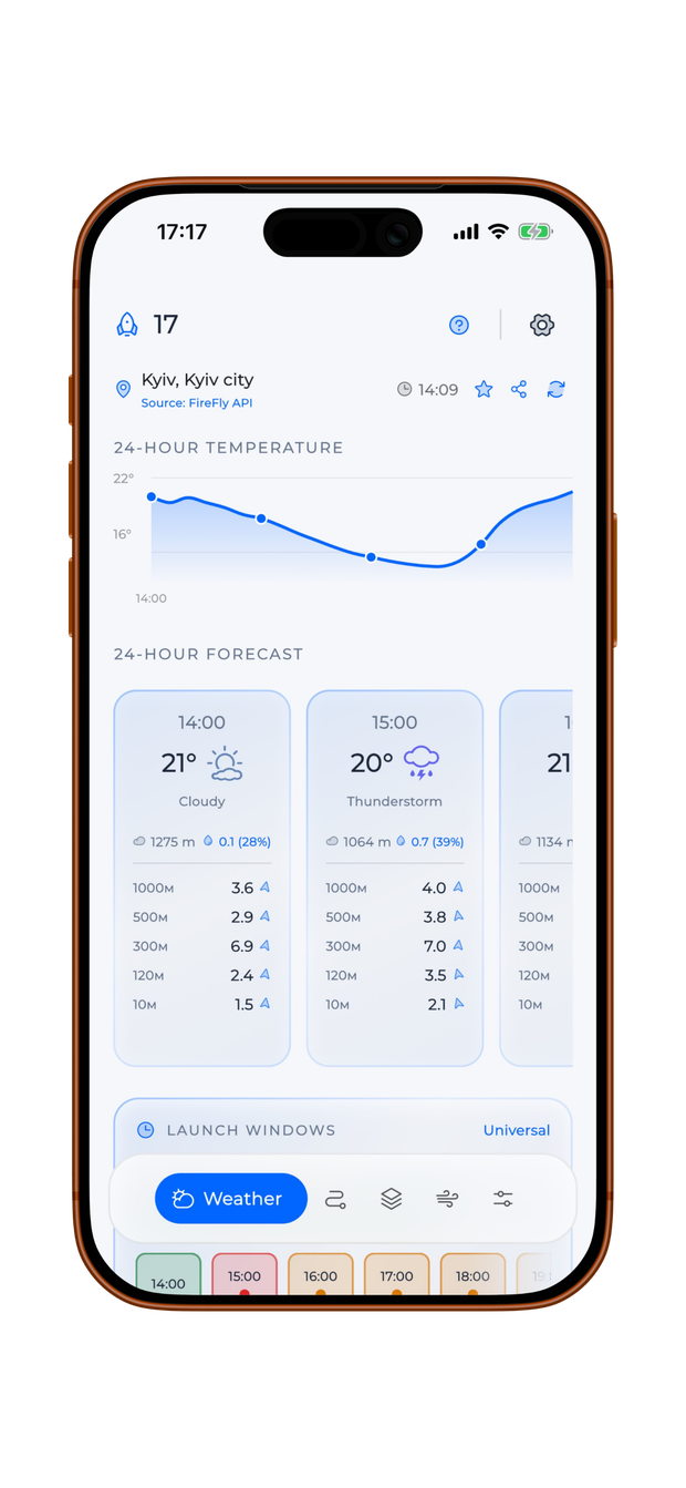
Hourly forecast for confident decisions
-
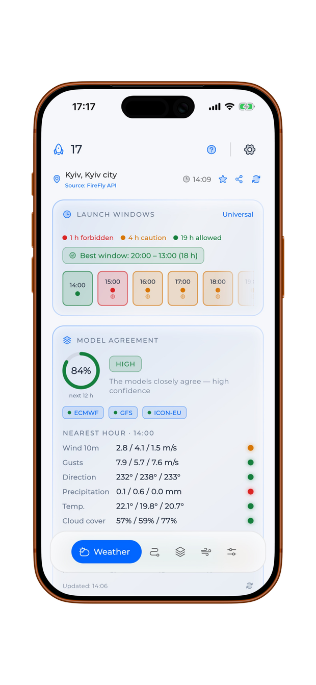
Flight windows — fly at the right time
-
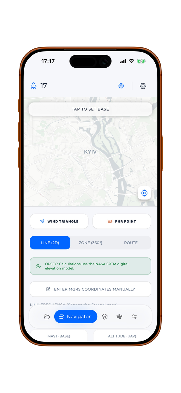
Flight planning for precision missions
-
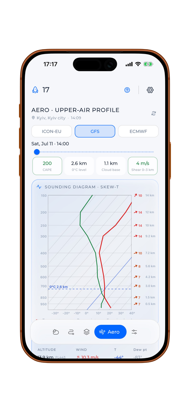
Altitude profile — ground to stratosphere
-
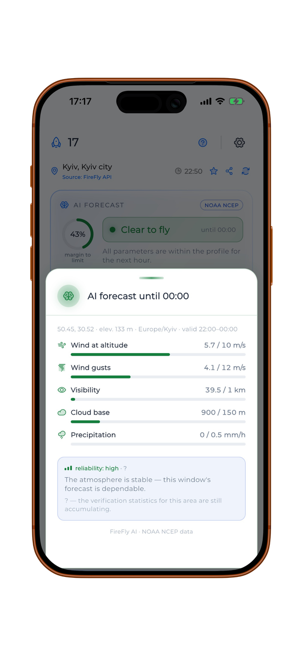
AI forecast with a confidence level, in plain words
How it works
Three steps to a confident decision
-
Set up your drone
Set your aircraft's limits once, or pick one of 50+ ready-made profiles — quadcopter, FPV or fixed wing.
-
The app watches the weather
17 METEO tracks wind, rain, visibility and signal, checks the weather models against each other — and warns you the moment something's wrong.
-
Get the verdict
Green, yellow or red — with the reasoning, a confidence level and a forecast of the next green window.
Pilot toolkit
Deeper tools for demanding missions
When you need more than just “fly or not”, 17 METEO gives you professional-grade detail.
-
Upper air to FL450
Winds and temperatures up to FL450, Skew-T diagram, CAPE and freezing level.
-
Point of No Return (PNR)
Will the battery get you home — accounting for the wind along the route.
-
Wind triangle
Actual ground track and ground speed in the current wind.
-
Radio line-of-sight
Fresnel zone between points, 360° coverage, MGRS coordinates.
-
Density altitude & icing
Density altitude, turbulence and icing risk for precise planning.
-
Astronomy
Twilight, moon phase and thermal crossover for mission planning.
Works everywhere
The whole planet. With or without internet.
The same forecast at any point on Earth — and offline maps with a forecast cache keep you in the game where there's no connectivity. Built in Ukraine — proven by pilots where weather decides everything.
-
Worldwide coverage
The same forecast at any point on the planet — from a city block to the open sea.
-
Offline maps & cache
Maps and the saved forecast keep working where there's no network.
-
Home-screen widget
Readiness status at a glance — without even opening the app.
-
Apple Watch
The colored verdict, temperature and limiting factor — on your wrist.
-
Team briefing
Share your weather readiness in one tap.
-
Alerts & regional map
Air-raid alerts and an animated regional weather map — available in Ukraine.
Privacy & OPSEC
No account. No tracking. No personal data.
OPSEC by default — so nothing sensitive ends up where it shouldn't. The readiness verdict is computed right on your phone, and the app collects and transmits nothing. There's simply nothing to leak.
- Verdict computed on-device — no cloud profile
- Anonymous weather requests, no account
- No personal data collected or shared
- Fully localized in English and Ukrainian
FAQ
Frequently asked questions
What does the traffic light show?
Green means good to fly, yellow means fly with caution, red means better hold off. The verdict is matched to your exact drone's limits — and it always tells you why.
What is the AI forecast, and can I trust it?
It's a go/no-go verdict powered by the NOAA AIGFS neural weather model — the next-generation technology reshaping world meteorology right now. The verdict comes with a confidence level and is automatically cross-checked against a classical physical model, while the model-agreement card shows whether ECMWF, GFS and ICON converge. Like any forecast, it's a probability, not a guarantee — that's why the app always shows how sure it is.
Is 17 METEO free?
Yes, completely free on both the App Store and Google Play. No ads, no subscriptions.
Does the app collect my data?
No account, no tracking, no personal data. The readiness verdict is computed right on your phone, weather requests are anonymous, and the app collects and transmits nothing — there's simply nothing to leak. OPSEC by default.
Where does the weather data come from?
17 METEO runs on its own weather infrastructure and compares several forecast models — ECMWF, GFS, ICON and the NOAA AIGFS neural model — rather than relying on a single public source. That's what gives you wind and gusts at every altitude and an honest read on how much today's forecast can be trusted.
Does 17 METEO work outside Ukraine?
Yes — coverage is the whole planet: the same forecast at any point on Earth. Offline maps and the forecast cache keep you in the game where there's no connectivity.
Does it work without internet?
You need a connection to download the forecast. Once it's loaded, the readiness verdict, offline maps and the pilot calculators keep working with no network — handy in the field with a weak signal.
How is it different from regular weather apps?
Regular weather apps show you raw weather and leave the judgment to you. 17 METEO turns it into a fly-or-wait verdict matched to your exact drone's limits, explains why, and predicts the next green window — plus an AI forecast with a confidence level, a GNSS spoofing monitor and OPSEC by default.
What are the naval and ground modes?
Naval mode shows wave height, sea state and departure windows for surface platforms. Ground mode covers soil trafficability, night-frost windows, fords and control-link range.
How accurate is the wind-at-altitude forecast?
Wind and gusts are modelled layer by layer from upper-atmosphere data, so you see the profile your drone actually climbs through instead of a single ground reading. Like any forecast it's a probability, not a guarantee — that's why the verdict always shows the reasoning behind it. And an external Bluetooth anemometer gives you ground-truth wind in the field.
Is there a widget or an Apple Watch app?
Yes. A home-screen widget shows the readiness status at a glance, and on Apple Watch you get the colored verdict, temperature and the limiting factor — without reaching for the phone.
Who is 17 METEO for?
For people who fly for a living: aerial photo and video, FPV, inspections, search and rescue, agriculture — any unmanned platform. You can customize the dashboard and keep only what you need.
What advanced calculations are available?
Upper air to FL450 with a Skew-T diagram, CAPE and freezing level, point of no return (PNR), wind triangle, radio line-of-sight with Fresnel zone, 360° coverage and MGRS coordinates, density altitude, icing risk, plus astronomy: twilight, moon phase and thermal crossover.
Less guesswork. More confidence before takeoff.
Download 17 METEO — professional weather for drone pilots. Completely free, no ads, no subscriptions.